Crop View.
Identify vegetation variances faster.
Creation of potential and application maps with Crop View
With the Crop View component, you can detect vegetation differences in your fields easily and quickly. You can also create application maps based on vegetation or yield potential maps to ensure an optimal and resource-efficient cultivation of your fields and expand your field catalogue to include section-specific cultivation.
Raw data from Earth observation satellites (Sentinel 2 satellites belonging to the European Space Agency), which is then condensed into field-specific information, forms the basis of this component. You can use it as a basis when making decisions about section-optimised interventions.

Scope of use of the Crop View component
- The component is intuitive to use and is an easy way for you to take your first steps in Precision Farming.
- There are different filter options that can be applied to the fields (field number, field name, farm, crop, variety).
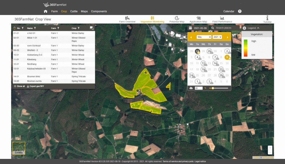
- With the vegetation monitoring within the field boundaries, which is done in almost real-time, you can detect vegetation differences at a glance.
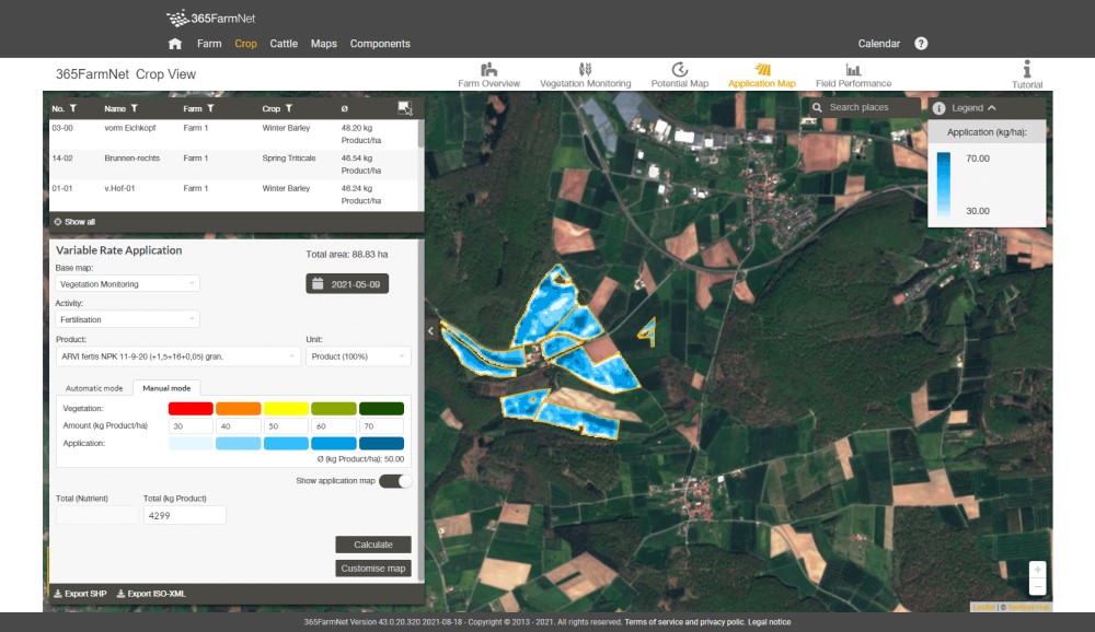
- You can create zoned vegetation and potential maps for your fields which can then be used as a basis for generating application maps for sowing, fertilising and plant protection activities. The application maps can be exported either in Standard Shape Format or in ISO-XML format.
- It is possible to have a field comparison that shows the average vegetation development.
- You can track the growth of the crops by regularly updating the satellite data.
- You can rework the created application maps individually.
Fertilisation, sowing and plant protection with Crop View
Vegetation is often distributed differently in a field. This can be due to many different things, such as the relief, water supply or distribution of nutrients. These differences can influence, amongst other things, the need for fertilisers, seeds and plant protection products. You can view these details in vegetation and yield potential maps with the Crop View component which uses satellite maps as a basis. Vegetation maps show the relative amount of vital vegetation at a specific point in time. Yield potential maps show the long-term, stable vegetation distribution in five zones and are calculated over a longer period of time and based on multiple vegetation maps. Both map types form the basis for the creation of application maps which can be used to help you sow and fertilise in a site-specific way that conserves resources.
Sowing - Create vegetation and potential maps with satellite data to form basis for your application maps for a section-specific sowing.
Fertilising - Determine the optimal fertilisation distribution based on application maps that have been created using vegetation and potential maps.
Plant protection - Generation of section-specific application maps according to your specifications. Creation of a spray mixture based on the plant protection products recorded in the platform.
Harvesting - Monitor the ripening of your crops and plan your crop yield. Compare the degrees of ripeness of different fields to determine which order to harvest in.
Data sharing
In order to be able to use this partner component, it is important that the following data categories are released. With the data release, I hereby agree that the individual data from the data categories listed are also transferred to the provider of the partner component, in order that they can make available the functionalities requested in the partner component.
- Operating information
- Field information
- Information on the crops cultivated
- Information on varieties
Test conditions
- 10-day access free of charge.
- The test phase ends automatically, without further obligations.
- In test mode this component may have reduced functionality compared with paid mode.
Price
- The minimum price for the component is 18.75 €/month excl. VAT. This enables you to use the component for 50 ha.
- Differential pricing depending on the ha-size of your operations, for example, for 100 ha the price is 31.25 €/month excl. VAT.
Contract terms
- Minimum term is 1 month.
- After the minimum term has expired, the contract is extended automatically every month for one month.
- After the minimum term has expired, the contract can take effect at any time canceled at the end of the current billing month.
- The cancellation takes place by unsubscribing from the module online in the 356FarmNet Shop.
- Settlement takes place together with other booked modules, in the first month of use, if necessary, pro rata billing for the Module.
- The billing is based on the size of the company at the end of the billing month. Changes in farm size affect the monthly price of the Module.
Note:
The module Crop View is only available in Germany, France, Austria, Poland and Switzerland.
